
The Manager of the Boora project welcomes our group

The sign shows the walking and cycling routes. Long or short
walks, viewing various aspects of the site, can be planned. We
chose the red route (11 km) with a detour through
the Sculpture Park (an additional 3 km). The entire walk
being on the flat was completed in an unhurried walk
in three hours.

The walk begins at the Visitor Centre, with a cup of
coffee or tea and a bite of food. What appears to be paper
boats are sculptures of, yes, paper boats.
This lake, right beside the Visitor Centre is called
Loch an Dóchais ("Hope Lake") and caters for
people who can't walk or cycle too far.
Fishermen (and women) in wheel chairs can park their
chairs against low wooden rails around the lake.

Lightly raining outside, we put on our rain-gear

And set out to view the Sculpture Park.

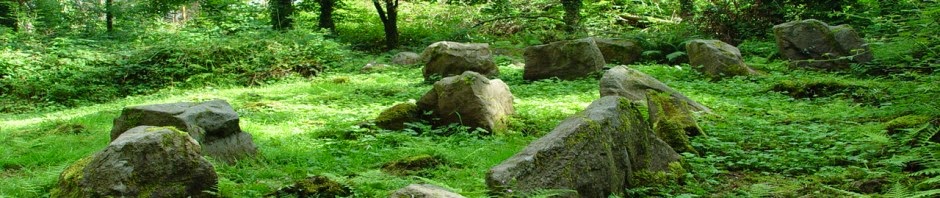
The sculptures are made from debris of old machinery
used in the exploitation of the bog. Here we
see a reminder of the old bog trains.

Fresh green of spring and gorse bloom along a stream

We continue on our journey.

Bog engine and trailer, a sculpture reminding us
of the park's industrial past.


Old machinery re-used.

Members of the Brian Boru Walking Club
on the Sculpture Park/ Red Route

I guess that there is a sign in Sydney telling you
by whom that great bridge was designed. Likewise
here.

Sculpture reminding us of the industrial past

Three triangles made of old beams, held together
by scraps of old metal.

Shapes reminiscent of the towers of redundant
peat-burning electricity generation stations.

Another view of the three triangles
Stream re-establishing ancient ecology system.

Sculpture reminiscent of stacks of logs of the past.

Sculpture made of scraps, reminds us of
a stone, skimming across the water.

An old peat-tipper device, sculpturally re-assigned to a
a new task, as a resting and viewing station.

Looking through the hut's slits gives you a different,
wide-angled, view of the scene.

An island naturally forms in the lake.

Naturally developing flora.

Bog oak (old timbers preserved for thousands
of years immersion in the bog) used to build
a tepee, a structure that might have
been used by the Mesolithic hunter/ gatherers
who rested here.

The tepee entrance.

Looking up at the ceiling of the tepee.

A stream enters the tepee and goes underground at the
central stone.

A wooded area.

The various routes through the park are well
sign-posted.

The Offaly Way is a more extensive walk trough
the County.

Rough grass-land.

This notice tells the story of the Mesolithic people
who rested here in the days before the bog developed -
8,000 years ago.

Peat-land workers discovered these standing stones
below the bog, as well as what appeared to be a stone roadway,
and called in the archaeologists
to have a look. The standing stones were merely deposited
by the receding ice at the end of the Ice-Age.
The "stone road" turned out to be the stone-strewn
shore of an ancient lake.
However, evidence of human habitation, such as
an abundance of stone tools, were found in the vicinity and
dated to 6,000 BC, or so. No remnants of structures were
found, indicating that these hunter/ gatherers
were, like us, only stopping temporarily
as they passed through.

This clamping of stones is a modern artistic
expression rather than a historic relic.

Examine the stones, to find multiple fossils.

The ancient bog-oak trunks furnish a suitable
seating for the eco-tourists, who stop for
a break. They take nothing from the site and
leave nothing behind.

A plaque seems to have been attached formerly
to the stone, but left remnants suggesting
the eyes of a face.

The self-seeding birch woods.

Last year's crop of bulrushes.

Love will never be out of fashion
as long as the gorse is in bloom (an old saying).

The fir trees were, undoubtedly planted, but
the birch self-seeded. Pause for a moment
and listen to the multitude of birds
singing!

The old bog road, once compressed by traffic below
the level of the old bog, now sits above the cut-out
bog, now planted with trees.

The cycle-track is 22 km long (but shorter
routes can also be chosen).

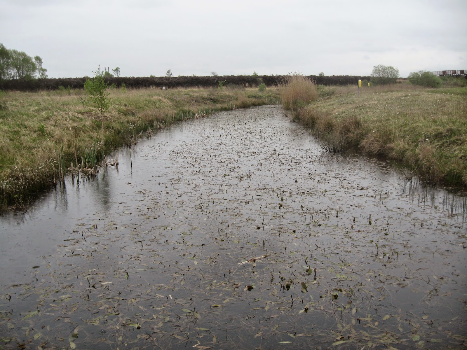
Drains; the first step in the exploitation of the bogs,
essential to cultivation.

Remnants of an old forest. Over thousands of years,
debris of old growth converted into water-saturated
peat and engulfed the forests.

The walkers continue on their way.

Work continues on the development of the Discovery
Park. From our touring path, we can see this road
which serves the site workers and their machines.

An abandoned machine, left here as a reminder
of the industrial past.

When the bog was cut out, various different
bases were found. Here we see boulder-clay,
which is quite unsuitable for tillage.

The brown/ grey area seems to have been
treated with weed-killer to prepare for
re-seeding with plant suitable to maintain
the emerging grey partridge bio-system.

A somewhat camouflaged grey partridge
feeder. The seed drops through a hole in
the bottom of the plastic bucket.

Clear notices of the grey partridge conservation
area. The project is restoring the population
of grey partridge and the whole connected eco-system

Poor quality growth

Ploughing of poor quality flora for re-seeding
with flora suitable to sustain the grey-partridge
eco-system.

Grey grass to the left; renewed field to the right.

Food for the grey partridge.

Remnant of a bog oak.

This was a bog road.

The bog, cut out now on both sides,
was three times as high as the remnant
bog road, compacted by human traffic.

Work in progress: an artefact recalling the various
vernacular wall-building practices from the
four provinces of Ireland.

Artefact, arranging bog-oak uprights, in decling
heights to the lake edge.

The Pavilion under construction, using old remnants.

Taking in the information.

Bull-rushes (last year's decayed stems) by lakeside


A lake-side thatched hut.

The slit windows, again, provide a wide-ange
view of the lake, allowing us to see from
a different perspective.


Wide-angle view from the lakeside hut.


Not many photos of the fauna: for that you need a
telephoto lens.


Jonathon Livingstone Seagull, I presume.

Anglers.

Walk nearing its end, a reminder that bicycles
are now to be hired from the Visitor Centre,
opened only six months' ago

The end in sight now.

The Visitor Centre (from the side),
clad with Canadian cedar wood, which will
grey with age. Now for another cup of
tea or coffee, and maybe a bun or Panini.

Geese by Finnamore Lake, also within the
Discovery Park, but not on the Red Route,
where we stopped for a moment on our
minibus taxi on the way back to Tullamore.

Finnamore Lake.

A nip of Tullamore Dew, in the whiskey-maker's
visitor centre in Tullamore. On the wall behind are
a selection of tools my father would have used
when he was an apprentice joiner in the distillery
at Clara. That distillery was burnt down by iregulars
in the Civil War of 1922, whereupon my father
migrated to Dublin.

A lighting artefact in the Tullamore Dew visitor
centre. What do the letters "DEW" in the name stand for?
"Daniel Edward Williams," who joined
the company at the lowest level, in his teens,
rose to become Chief Executive, gave his initials
to the brand, and created the famous
slogan, "Give every man his DEW."
No comments:
Post a Comment